Ponds and Lakes
Ponds and lakes form in depressions in the land. Lakes form in large, deep depressions. Ponds, like the one in Figure 4, form in smaller depressions and tend to be smaller and shallower than lakes. Both lakes and ponds usually drain into streams.

What is the difference between a pond and a lake?
Water Beneath the Surface
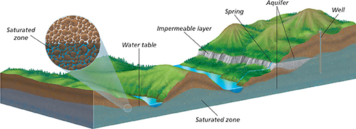
About a quarter of all fresh water is groundwater. Close to the surface, the pore spaces in rock and soil are filled with air. Deeper below the surface is the saturated zone, a region where the pore spaces are entirely filled with groundwater. The top of the saturated zone is called the water table. Look at Figure 5 to see the saturated zone and the water table. The shape of the water table is usually similar to the ground surface above it. Water flows slowly from high elevations of the water table to low elevations. Lakes and streams are usually found where the ground is below the water table. The level of the water table rises and falls, depending in part on the amount of rainfall. During droughts, the water table can drop significantly.
Water flows more easily through some rocks than others. A rock is permeable if water can easily pass through it. Rocks like sandstone and limestone are permeable. A permeable rock layer that is saturated with water is called an aquifer. In many parts of the world, people rely on aquifers as a source of water for drinking and for agriculture. They can withdraw water from an aquifer by drilling a well below the water table. Aquifers are refilled, or recharged, as rainwater seeps into them.
Rocks are impermeable if water cannot easily pass through them. Shale and unbroken granite are examples of impermeable rock. In places where an impermeable rock layer is exposed on a hillside, water may seep to the surface. Groundwater in loose rock or soil above the impermeable layer flows out of the hillside as a spring.
Figure 4 Ponds like this one form when water collects in small, shallow depressions. Many ponds support lush plant growth and animal life.
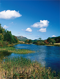
Figure 5 Groundwater makes up about one quarter of all fresh water. In the saturated zone, groundwater flows in the pore spaces in underground rock. Interpreting Diagrams What is the source of the water in a spring?