Change text size


Show/Hide TOC

Map Skills
Understanding Globes
A globe is a scale model of Earth. It shows the actual shapes, sizes, and locations of all Earth's landmasses and bodies of water. Features on the surface of Earth are drawn to scale on a globe. This means that a small unit of measure on the globe stands for a large unit of measure on Earth.
Parallels of Latitude
Geographers divide the globe along imaginary horizontal lines called parallels of latitude. One of these latitude lines is the equator, located halfway between the North and South poles. Parallels of latitude are measured in degrees (°). One degree of latitude represents a distance of about 69 miles (111 kilometers).
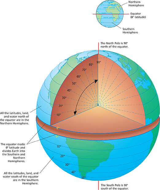
Table of Contents
Physical Science
CHAPTER 1 Science Skills
1.1 What Is Science?
1.2 Using a Scientific Approach
1.3 Measurement
1.4 Presenting Scientific Data
CHAPTER 1 Study Guide
CHAPTER 1 Assessment
CHAPTER 2 Properties of Matter
2.1 Classifying Matter
2.2 Physical Properties
2.3 Chemical Properties
CHAPTER 2 Study Guide
CHAPTER 2 Assessment
CHAPTER 3 States of Matter
CHAPTER 4 Atomic Structure
4.1 Studying Atoms
4.2 The Structure of an Atom
4.3 Modern Atomic Theory
CHAPTER 4 Study Guide
CHAPTER 4 Assessment
CHAPTER 5 The Periodic Table
5.1 Organizing the Elements
5.2 The Modern Periodic Table
5.3 Representative Groups
CHAPTER 5 Study Guide
CHAPTER 5 Assessment
CHAPTER 6 Chemical Bonds
6.1 Ionic Bonding
6.2 Covalent Bonding
6.3 Naming Compounds and Writing Formulas
6.4 The Structure of Metals
CHAPTER 6 Study Guide
CHAPTER 6 Assessment
CHAPTER 7 Chemical Reactions
7.1 Describing Reactions
7.2 Types of Reactions
7.3 Energy Changes in Reactions
7.4 Reaction Rates
7.5 Equilibrium
CHAPTER 7 Study Guide
CHAPTER 7 Assessment
CHAPTER 8 Solutions, Acids, and Bases
8.1 Formation of Solutions
8.2 Solubility and Concentration
8.3 Properties of Acids and Bases
8.4 Strength of Acids and Bases
CHAPTER 8 Study Guide
CHAPTER 8 Assessment
CHAPTER 9 Carbon Chemistry
9.1 Carbon Compounds
9.2 Substituted Hydrocarbons
9.3 Polymers
9.4 Reactions in Cells
CHAPTER 9 Study Guide
CHAPTER 9 Assessment
CHAPTER 10 Nuclear Chemistry
10.1 Radioactivity
10.2 Rates of Nuclear Decay
10.3 Artificial Transmutation
10.4 Fission and Fusion
CHAPTER 10 Study Guide
CHAPTER 10 Assessment
CHAPTER 11 Motion
11.1 Distance and Displacement
11.2 Speed and Velocity
11.3 Acceleration
CHAPTER 11 Study Guide
CHAPTER 11 Assessment
CHAPTER 12 Forces and Motion
12.1 Forces
12.2 Newton's First and Second Laws of Motion
12.3 Newton's Third Law of Motion and Momentum
12.4 Universal Forces
CHAPTER 12 Study Guide
CHAPTER 12 Assessment
CHAPTER 13 Forces in Fluids
13.1 Fluid Pressure
13.2 Forces and Pressure in Fluids
13.3 Buoyancy
CHAPTER 13 Study Guide
CHAPTER 13 Assessment
CHAPTER 14 Work, Power, and Machines
14.1 Work and Power
14.2 Work and Machines
14.3 Mechanical Advantage and Efficiency
14.4 Simple Machines
CHAPTER 14 Study Guide
CHAPTER 14 Assessment
CHAPTER 15 Energy
15.1 Energy and Its Forms
15.2 Energy Conversion and Conservation
15.3 Energy Resources
CHAPTER 15 Study Guide
CHAPTER 15 Assessment
CHAPTER 16 Thermal Energy and Heat
16.1 Thermal Energy and Matter
16.2 Heat and Thermodynamics
16.3 Using Heat
CHAPTER 16 Study Guide
CHAPTER 16 Assessment
CHAPTER 17 Mechanical Waves and Sound
17.1 Mechanical Waves
17.2 Properties of Mechanical Waves
17.3 Behavior of Waves
17.4 Sound and Hearing
CHAPTER 17 Study Guide
CHAPTER 17 Assessment
CHAPTER 18 The Electromagnetic Spectrum and Light
18.1 Electromagnetic Waves
18.3 Behavior of Light
18.4 Color
18.5 Sources of Light
Incandescent Light
CHAPTER 18 Study Guide
CHAPTER 18 Assessment
CHAPTER 19 Optics
19.1 Mirrors
19.2 Lenses
19.3 Optical Instruments
19.4 The Eye and Vision
CHAPTER 19 Study Guide
CHAPTER 19 Assessment
CHAPTER 20 Electricity
20.1 Electric Charge and Static Electricity
20.2 Electric Current and Ohm's Law
20.3 Electric Circuits
20.4 Electronic Devices
CHAPTER 20 Study Guide
CHAPTER 20 Assessment
CHAPTER 21 Magnetism
21.1 Magnets and Magnetic Fields
21.2 Electromagnetism
21.3 Electrical Energy Generation and Transmission
CHAPTER 21 Study Guide
CHAPTER 21 Assessment
CHAPTER 22 Earth's Interior
22.1 Earth's Structure
22.2 Minerals
22.3 Rocks and the Rock Cycle
22.4 Plate Tectonics
22.5 Earthquakes
22.6 Volcanoes
CHAPTER 22 Study Guide
CHAPTER 22 Assessment
CHAPTER 23 Earth's Surface
23.1 Fresh Water
23.2 Weathering and Mass Movement
23.3 Water Shapes the Land
23.4 Glaciers and Wind
23.5 The Restless Oceans
23.6 Earth's History
CHAPTER 23 Study Guide
CHAPTER 23 Assessment
CHAPTER 24 Weather and Climate
24.1 The Atmosphere
24.2 The Sun and the Seasons
24.3 Solar Energy and Winds
24.4 Water in the Atmosphere
24.5 Weather Patterns
24.6 Predicting the Weather
24.7 Climate
CHAPTER 24 Study Guide
CHAPTER 24 Assessment
CHAPTER 25 The Solar System
25.1 Exploring the Solar System
25.2 The Earth-Moon System
25.3 The Inner Solar System
25.4 The Outer Solar System
CHAPTER 25 Study Guide
CHAPTER 25 Assessment
CHAPTER 26 Exploring the Universe
26.1 The Sun
26.2 Stars
26.3 Life Cycles of Stars
26.4 Groups of Stars
26.5 The Expanding Universe
CHAPTER 26 Study Guide
CHAPTER 26 Assessment
Skills and Reference Handbook