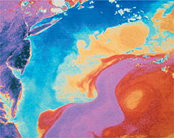
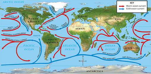
Global surface currents reflect the effects of wind patterns in the atmosphere. In general, currents of warm water flow away from the equator along the east side of continents. Currents of cold water flow away from the polar regions along the west side of continents. One major current is the Gulf Stream, which carries warm water from the Gulf of Mexico to the North Atlantic Ocean. Figure 28 shows a satellite image of the Gulf Stream. Another is the California current, which carries cool water from the Gulf of Alaska south along the west coast of the United States.
Figure 27 Prevailing wind patterns drive the ocean's surface currents.
Interpreting Maps What current flows south along the west coast of North America? Is it warm or cold?
Deep Currents
Unlike surface currents, deep currents are not caused by winds.  Deep ocean currents are caused by differences in the density of ocean water. Denser water results from colder temperatures or higher salinity. Because deep ocean currents are affected by density, they are called density currents. Density currents are responsible for a slow mixing of water between the surface and deeper ocean. For example, a density current flows south through the Atlantic Ocean. This density current forms near Greenland in an area where very cold, salty water sinks into the deep ocean. Another density current in the Atlantic forms near Antarctica and flows north.

What are density currents?
Figure 28 This satellite image of the Atlantic Ocean shows the Gulf Stream, which carries warm water northward from the Gulf of Mexico toward the British Isles. The image has been enhanced so that the colors indicate water temperature (Red indicates warmer water and blue indicates cooler water.)