


Although the weather maps you see in newspapers or on TV are useful to most people, meteorologists need additional information on maps. For example, temperatures might be plotted and analyzed on a map using isotherms. An isotherm is a line on a map that connects points of equal air temperature. With this kind of map, a meteorologist can quickly see temperature patterns.
A comprehensive weather map that meteorologists prepare and use is a summary of weather conditions at a given moment for a given region. This kind of weather map typically includes information about weather systems and fronts. It also includes specific locations where weather data have been collected. More information on this type of map is included in Appendix F.
Figure 29 shows a simplified weather map smilar to what you might find in your local newspaper. Notice that temperature data are displayed using a series of colored bands that group regions in tendegree temperature intervals. Also notice that there is a tropical storm near New Orleans and a hurricane near Cuba on the weather map. Both are low-pressure centers. To the left of the map is a key for weather symbols used on such maps.
The lines on this weather map are isobars. An isobar is a line that connects points of equal air pressure. Notice that the isobars on this map are plotted at intervals of 4 millibars. Isobars help meteorologists, such as the woman shown in Figure 30, to identify the centers of high- and low-pressure systems and the locations of fronts.
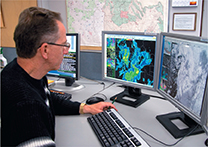
Figure 30 Meteorologists use computers to help forecast the weather.

Section 24.6 Assessment
Reviewing Concepts
 What are some of the technologies meteorologists use to collect weather data?
- How do meteorologists show differences in temperature and pressure on weather maps?
Explain how meteorologists use Doppler radar to track and predict the weather.
How do meteorologists use high-speed computers to help forecast the weather?
Describe the type of information that is typically shown on the weather maps prepared by meteorologists.
Critical Thinking
Inferring Why might a meteorologist want to compare today's weather map with yesterday's weather map?
Applying Concepts Why can't meteorologists accurately forecast the weather beyond a period of about a week?