


Fronts
Air masses don't stay where they form. They move with the circulation of air throughout the world. Recall that convection currents cause warm air near the equator to move toward the poles and cold air at the poles to move toward the equator. Polar air masses, therefore, tend to move toward the equator, and tropical air masses tend to move toward the poles. These air masses collide in the middle latitudes.
As an air mass moves, it tends to retain the properties of the region where it formed. So, a continental polar air mass retains the low temperatures and dryness of its source region as it moves south. Likewise, a maritime tropical air mass retains the high temperatures and moisture of its source region as it moves north. When such different air masses meet, they ordinarily don't mix. Instead, a boundary forms between them.
The sharply defined boundary that forms when two unlike air masses meet is called a front. For example, when a continental polar air mass moves southeast and collides with a maritime tropical air mass, a front forms between the two. Clouds and precipitation often accompany fronts.  There are four types of fronts: cold fronts, warm fronts, stationary fronts, and occluded fronts.

What is a front?
Cold Fronts
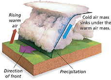
In North America, a cold continental polar air mass often moves southeastward into the Midwest. There, it may collide with a maritime tropical air mass from the Gulf of Mexico. At the boundary between the two air masses, a cold front forms. A cold front occurs when a cold air mass overtakes a warm air mass.
Figure 21 shows what happens when a cold front forms. Because cold air is denser than warm air, the cold air mass remains close to the ground and moves underneath the warm air mass. The cold air mass forces the warm air mass to rise. Cold fronts usually move quickly and are relatively steep, so the warm air mass is often lifted rapidly.
Figure 21 A cold front forms when a cold air mass overtakes a warm air mass.
The rapid rise of warm air often produces cumulus and cumulonimbus clouds. Strong winds, severe thunderstorms, and large amounts of precipitation are often associated with cold fronts. However, because the slope of a cold front is steep and such fronts travel quickly, the severe weather usually lasts for only a short time. Then, as the front passes, the cold air mass settles in, the skies clear, and temperatures drop.