Warm Fronts
Imagine that a continental polar air mass has settled in the Midwest and a maritime tropical air mass moves toward it from the southeast. As the air masses collide, a warm front results. A warm front occurs when a warm air mass overtakes a cold air mass.
Figure 22 shows what happens when a warm front forms. Because the cold air is denser, it remains close to the ground. The advancing warm air mass rises up over the cold air mass. The surface of a warm front is usually less steep than that of a cold front, as you can see by comparing Figures 21 and 22. A warm front has a gentle slope because the advancing warm air mass gradually moves up and over the cold air mass.
Figure 22 A warm front occurs when a warm air mass overtakes a cold air mass.
Applying Concepts What types of weather are associated with cold fronts and warm fronts?
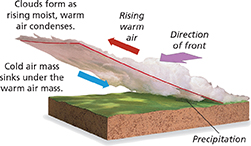
As the warm air rises, stratus clouds form. If the warm air mass contains a large amount of moisture, there will be a steady rain. Occasionally heavy showers or thunderstorms occur. Once the front has passed, the warm air mass settles in. The skies are mostly clear, often with some cumulus clouds present, and temperatures rise.
Stationary Fronts
The clash of air masses is not always as simple as those that produce cold fronts and warm fronts. Sometimes when two air masses converge, neither air mass overruns the other. Rather, a front forms, and either stays where it formed or moves slowly. When two unlike air masses have formed a boundary but neither is moving, the front is called a stationary front. Stationary fronts often result in clouds and steady rain or snow for several days.
Occluded Fronts
Another kind of front can occur because cold fronts generally move faster than warm fronts. An occluded front forms when a warm air mass is caught between two cooler air masses. The colder air masses force the warm air mass to rise, cutting it off from the ground and trapping it between the two cold air masses. As this warm air rises and cools, its water vapor typically condenses. As a result, occluded fronts are generally accompanied by cloudy skies and precipitation.