Air masses can vary greatly. Think of the differences in the air above the Gulf of Mexico and the air above northwestern Canada. The first property you might think of is temperature. It's usually a lot warmer near the Gulf of Mexico than it is in Canada. You might also think of humidity. The air above the Gulf of Mexico contains more water vapor than the air above northwestern Canada. Each type of air mass reflects the characteristics of the region where it formed. An air mass that forms over water, for example, contains more water vapor than one that forms over land. An air mass that forms over the Arctic is much colder than one that forms over the tropics.
Air masses are classified according to whether they form over water or land, and the latitude where they form. A maritime air mass forms over water. A continental air mass forms over land. An air mass that forms north of 50° north latitude or south of 50° south latitude, where it is often extremely cold, is called a polar air mass. An air mass that originates in the tropics, where it is warm, is called a tropical air mass.
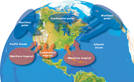
The air masses that most affect weather in North America include maritime polar air masses, continental polar air masses, maritime tropical air masses, and continental tropical air masses. As shown in Figure 20, maritime polar air masses originate over the frigid North Pacific and North Atlantic oceans. They are cool and moist, and often bring heavy precipitation to coastal areas. Continental polar air masses form over northern Canada and bring cold, dry air to the central and eastern United States. Maritime tropical air masses originate over the Gulf of Mexico and warm oceans to the south. They bring warm, moist air and are often accompanied by fog or rain. Continental tropical air masses form over northern Mexico and dry areas of the Southwest. They bring hot, dry air to the southern Great Plains.
Figure 20 Air masses that form in different regions affect North American weather. Interpreting Diagrams What type of air mass is moving toward the north- western United States? What type of air does it contain?